Small quake shakes earth near lake, no damage in wake
MILLEDGEVILLE, Ga. — No, it wasn’t an early April Fools’ Day prank, a low-magnitude earthquake really did rumble the area late Sunday night.
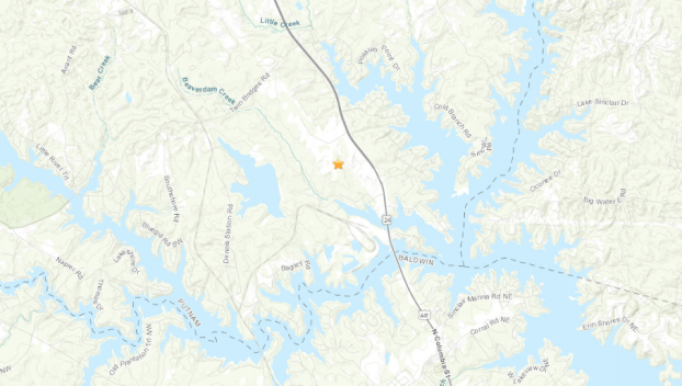
The United States Geological Survey (USGS) reported that a small quake, originating in southern Putnam County, registered a 2.3 on the Richter scale at 11:35 p.m. Sunday. No damage was reported, but many area residents that were still awake took to their social media accounts saying they felt some movement. The last such event occurred two years ago when two earthquakes similar in magnitude to the recent quake shook Hancock County and the surrounding area.
The coordinates provided by USGS pinpoint Sunday’s earthquake just north of the Baldwin-Putnam County line near where Georgia Power’s Plant Harllee Branch used to stand before its demolition 2 1/2 years ago. The earthquake’s depth was measured at 4.5 km or about 2.8 miles below the surface.
While the Richter scale is used to measure magnitude, the Modified Mercalli Intensity scale is actually a crowdsourced figure derived from the public’s reporting of the event. As of Monday afternoon, 55 people had contributed to what the USGS refers to as the “felt report” that asks respondents to gauge what they experienced at the time of the event. Unsurprisingly, an overwhelming majority of the reports were in either Baldwin or Putnam County, but others came from as far north as Atlanta and as far west as just over the Georgia-Alabama line.
The responses in the felt report for the local quake ranged between a 2, 3, or 4 on the Modified Mercalli Intensity scale, and quakes at those levels are characterized as producing weak to light shaking. The scale goes up to a 10, a designation given to earthquakes that produce extreme shaking and can destroy foundations of structures. Earthquakes like the one that hit locally are often felt but seldom produce any noticeable damage.
“[The USGS] can look at the distance and come up with a better understanding of how the earthquake that they measured for energy level based on a Richter scale actually affects the people living near it,” said Dr. Doug Oetter, Georgia College professor of geography. “They’ll translate the information into an intensity map, and that can help with local zoning ordinances and emergency evacuations.”
Earthquakes in this area aren’t all that uncommon, Oetter explained.
“The Oconee River valley occupies an area that has probably been a drainage area for a long, long time — we’re talking like 10s or 100s of millions of years since the Appalachian Mountain chain started forming almost 300 million years ago,” he said. “Oftentimes, rivers occupy places that had, for whatever reason, some sort of a geologic fault (crack in the bedrock) underneath it. That crack has probably been there for over 100 million years. Every so often, about 3 miles down, as the seismograph told us, the fault can slip because these are old structures that are moving around just a little bit. What I’ve heard is that a lot of times these are caused by the water in the reservoir.”
The reservoir, Lake Sinclair, can help create earthquake-favorable conditions on occasion.
“After a significant rain, especially if Georgia Power is holding onto their water, the level can come up and the rainwater can help lubricate things down underneath,” Oetter added. “The weight of the reservoir is one of the things that can help move those sediments around along that old fault. They have a name for it called, ‘reservoir-induced earthquakes.’ The ones we’ve seen tend to be focused in and around the lake. They usually tend to come when there’s a high water level at the lake, and a lot of them came on the heels of a significant precipitation event … People tend to forget how much water weighs.”
Georgia Power reported Monday that Lake Sinclair was 1.16 feet below what is known as “full pool,” which is listed at 340 feet. The level had gotten as high as 339.62 feet back in early March.