Idalia expected to make landfall as Category 3 hurricane
Published 11:03 am Monday, August 28, 2023
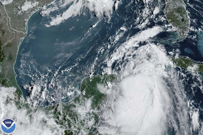
- RAGING IN THE YUCATAN: In this Monday, Aug. 28, 2023, 9:41 am ET satellite image provided by the National Oceanic and Atmospheric Administration, Tropical Storm Idalia moves between Mexico’s Yucatan peninsula, left, and Cuba, right.
THOMASVILLE- Thomas County Emergency Services gathered local officials for a weather briefing from the National Weather Service Tallahassee office on Monday morning in regard to Tropical Storm Idalia.
According to Senior Service Hydrologist Kelly Godsey, Idalia is expected to turn into a Category 3 Hurricane by the time it makes landfall later this week.
Trending
Hurricane watches are currently in effect for Indian Pass, moving eastward toward the Big Bend. The watches have been extended to Madison County, as well as the inward portions of Lafayette, Dixon and Taylor County.
Tropical storm watches are now in effect for the inward portions of Wakulla, Jefferson and Leon County.
“Idalia has continued to strengthen overnight and now has maximum sustained winds of 65 mph,” Godsey said. “The anticipation is that the hurricane will continue to strengthen all the way up the coast.”
Godsey explained Idalia is moving quickly, causing hurricane force winds to extend well beyond the immediate coast.
“This is going to be a large hurricane; this is going to be an intense hurricane and as a result, impacts are going to be seen well away from the center,” Godsey said. “Remember the cone is just where we expect the center to be two thirds of the time. Impacts can be felt well away from the cone.”
Godsey reminded those outside of the cone that they will likely still see impacts from Idalia.
Trending
“We are seeing Idalia pick up speed at about 7-8 mph and the speed will continue to pick up into the later hour and as we move into Tuesday,” he said. “This storm will be approaching our coastline late Tuesday night and into Wednesday.”
Based on the current track Idalia is following, Godsey said they are most concerned about Berrien, Brooks, Cook, Lanier and Lowndes County.
“We are seeing Idalia get better organized,” he said. “We are about 680 miles from Tallahassee at this point. As our wind speed increases, so do our threats and we are continuing to see those increase.”
The earliest predicted tropical storm force winds will arrive at 8 p.m. Tuesday along the coastline. However, Godsey believes it is likely it will not be felt until early Wednesday morning.
Godsey pointed out that there is a 4-5/10 chance that Lowndes and Lanier County will feel sustained tropical force winds.
“These are reasons why will be expanding the watches northward as we move into the hour,” he said.
Sustained heavy tropical force winds in an excess of 57 mph only have a 1/10 chance of being felt in Lowndes County.
Godsey said they have seen the Idalia model begin to shift eastward, but flash flooding is still possible, as the path continues to take shape.
“The environment ahead of this system is very favorable for continuing to strengthen it,” Godsey said. “We want folks to prepare for a major category 3 hurricane at landfall.”
Landfall is expected among the northern gulf coast of Florida, but there is still an amount of uncertainty with the forecast.
“There is the possibility Idalia could strengthen more and we could see a higher end Category 3,” Godsey said. “This is something we should be preparing for at this time.”
Although the track is still somewhat uncertain, a slight shift would not change the wind and rain impact, but would impact the storm surge.
Thomas County Schools and Thomasville City Schools were in attendance at the briefing and are still working on a plan. At this time, no school closures have been announced, but all Wednesday athletic events have been moved to Tuesday afternoon. Thomas County is currently developing a plan for sand bag handouts, if necessary.