Idalia looks to become Category 4 storm, cause life-threatening storm surge on Ochlocknee River
Published 11:13 am Tuesday, August 29, 2023
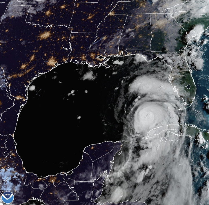
- CHURNING UP A STORM: Hurricane Idalia has continued to gain strength and is being considered a low level Category 4 Hurricane at this time. All residents are asked to make immediate preparations.
THOMASVILLE- The Thomas County Emergency Management Services continued to provide updates to local officials on Tuesday morning in regard to Hurricane Idalia, which is now being considered a possible low level Category 4 hurricane.
According to Senior Service Hydrologist Kelly Godsey, Idalia strengthened overnight and now has maximum sustained winds of 80 mph and is continuing to strengthen as it churns toward Florida.
Hurricane warnings are currently in effect for Indian Pass moving eastward toward Apalachee Bay, while tropical storm warnings are in effect for west of Indian Pass, including Mexico Beach.
“We have continued to see slightly gradual westward shifts,” Godsey said in his briefing. “If we see any further westward shifts, which we do anticipate, that could increase impact in the Central Florida/Big Bend area.”
While Idalia had a speed of 7-8 mph during yesterday’s briefing, Godsey said they have seen the hurricane increase speeds of up to 14 mph as of 9:30 a.m.
“We are less than 36 hours from landfall somewhere in the Big Bend and we expect Idalia to rapidly intensify later today,” he said.
Idalia has continued to become more organized, however Godsey explained that they still cannot predict a path for certain.
“As we hit the 36-24 hour mark, the cone will become more narrow, but the impact will be felt way beyond the center,” he said. “Any slight shift to the west or east will not make huge difference in the impact.”
The slight shift to the west would cause the National Weather Service to extend hurricane warnings into the inland portions of Wakulla and Leon county.
“This is something we are currently evaluating, but will probably have to do as we go on,” Godsey said.
As Idalia continues to organize, the wind speed probabilities become clearer for Southeast Georgia and the Big Bend.
“It is a mere certainty that sustained tropical storm force winds will occur,” Godsey said. “The wind speed probabilities have increased for South Georgia, especially Lowndes County, who have an 8 in 10 chance of seeing sustained tropical storm force winds.”
The earliest predicted
tropical storm force winds will arrive at 8 p.m. Tuesday along the coast, but the the Big Bend area will most likely not see any wind action until after midnight and into early Wednesday morning.
Ben Hill and Tift County have a 5 in 10 chance of seeing sustained tropical storm force winds.
Sustained heavy tropical force winds in an excess of 57 mph still have a low chance of being felt.
Godsey did produce a graphic of the possible worst case scenario, which showed Idalia moving on the most western route, which would cause hurricane force winds in portions of Thomas County.
Storm surge is a top concern of Godsey’s, who said this will be a life-threatening storm surge.
“Accounting for this westward shift, we may have to bring this warning up to Wakulla County for parts of the Ochlocknee River,” he said. “We may be as high as 6-9 ft., we are still refining that. When you get into 8-13 ft., this is a storm surge that is not survivable.”
Godsey asked everyone along those areas to make preparations immediately, as a storm of this intensity has never hit this portion of the country.
“It is entirely possible that this storm continues to gain intensity, so we are preparing for a low end Category 4 hurricane,” he said. “If the Hurricane Center increases just 5 knots, we are in a Category 4. We are right on that doorstop. We want folks to be preparing.”
In light of preparation, Thomas County’s eight garbage collection sites have sand bags that are available. They are limited to 12 bags per household and are self-serve.
New Covenant has opened a shelter for those who do not feel safe in their home. The shelter opened at 6 p.m. Tuesday evening and will remain open until further notice. A request has been submitted to the Red Cross, but they are unable to respond to shelter needs until after the storm.
Thomasville City Schools, Thomas County Schools and Southern Regional Technical College will all be closed on Wednesday, August 30, 2023 out of an abundance of caution. SRTC plans to resume classes on Thursday morning. All city and county schools will post updates through social media following the hurricane.


